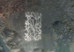
China's weird desert structures
[ ](/china/chn-spc/weird-desert-structures/attachment/china-desert-structure/” rel="attachment wp-att-5020)The Interwebz are awash with images of vast, unexplained structures in China’s Gobi desert. The first photos were of a site near Dunhuang, previously famous for being the historical cross-over point between China and countries to its West.
Since then, netizens have found various other sites, all bizarre in design and very mysterious. This looks set to develop into China’s equivalent of the Area 51 legends.
The sites are all within 100 miles from the headquarters of China’s space program. You can find them yourself on Google maps around the co-ordinates 40.452107,93.742118, just to convince yourself they’re not photoshopped (that was one of my first thoughts):
The general consensus seems to be that these structures are designed to be viewed from space, specifically by Chinese satellites. This theory was suggested by Jonathan Hill, a researcher at the Mars Space Flight Facility at Arizona State University (who seems to spend a lot of his time [debunking space-related rumours](http://www.google.com/search?q=Jonathan+Hill+Mars+Space+Flight+Facility+Arizona+State+University “Search for “Jonathan Hill Mars Space Flight Facility Arizona State University” on Google”)). It seems by far the most sensible explanation.
Alternative desert structure explanations
That of course hasn’t stopped a wave of stranger ideas, ranging from funny suggestions to conspiracy-theories. I’m using “alternative” in the most derogatory possible way here. Some of the wackier ideas:
- The structures are giant QR codes.
- They’re messages to aliens.
- Google Maps (where these images are being found) has been hacked by pranksters or even government agents from other countries.
- Scale replicas of real cities (usually suggested to be major American cities, surprise surprise).
- Nuclear weapons testing sites (burnt out vehicles can be seen at some of the sites, and some appear to feature various apparatus and replicas such as radio towers, water storage etc.)
- China is just screwing with Google Maps users.
And some more mundane explanations:
- Debris from digging / mining projects.
- The sites are indeed for satellite calibration (other countries that operate spy-satellites have similar structures set up). Furthermore, they’re surprisingly large, suggesting that China’s satellites have poor image resolution, so there’s really not a lot to worry about here.
I also think it’s worth pointing out that the sites could all be for very different purposes. There doesn’t seem to be particular reason to think they’re all for the same thing, other than that they’re big, odd and built near each other.
And finally, in the interest of balance, something strange in America.
